Drones and AI assist in mapping ecology, wildlife conservation
Wildlife safety organizations have now implemented remote tracing technologies as a modern conservation tool, letting small groups to observe and manage information from animals over a wide area. The world’s eyes have increasingly turned towards safeguarding of endangered species, climate change, plastics and air pollution in the recent past. Today, the provinces of Africa are getting more attention especially where poaching is threatening to wipe out endangered animals including rhinos, elephants, pangolins, and lions.
How AI is safeguarding wildlife?
Artificial intelligence when amalgamated with any existing modern technology not only intensifies its overall experience but also the performance. Keeping this phenomenon in mind, scientists and researchers are now integrating AI in various industries. With its wide usage, in almost every sector, AI has entered those areas that can help transform the ecology and its exploration. The use of smart-technology like AI and autonomous drones can help protect wildlife on a global level.
Till date, the most popular and successful AI based application has been Protection Assistant for Wildlife Security (PAWS). The AI-based tool estimates wildlife poaching based on officially-collected data and assessment through field tests. This platform predicts a heat map of poaching threats.
Over eight months of using PAWS in Uganda, it was confirmed that the predictions made led forest officials not only catch poachers but also spot traps at a much higher rate. This meant that every trap removed meant saving an animal’s life. PAWS also assisted park officials to design effective patrolling routes even on tough terrains. This platform is yet to see the light in India, but it has been tried and tested in South-East Asia and China and has yielded surprising results.
Impact of Connected Conservation
In 2015, Dimension Data, a South African based entity partnered with Cisco Systems to launch ‘Connected Conservation’. The sole aim of this project was to protect global wildlife through the use of modern technology. According to Dimension Data, 1,028 rhinoceros were killed in South Africa alone; that meant at least 3 rhinos killed per day. With this current rate by 2025, rhinoceros would be extinct. The Johannesburg based company also said that 27,000 elephants are killed year-on-year, with this rate by 2025, elephants would be reduced to a mere 160,000.
Their flagship project took place at Kruger National Park, South Africa. Poachers have been posing a great threat to both the rhinoceros and elephant population. From 2017 onwards, there was a radical change in the poaching figures. According to Bruce Watson, Group Executive, Cisco Alliance, Dimension Data, “The sanctuary saw an astonishing drop of 96% in rhinoceros poaching that eventually led ‘Connected Conservation’ project in Kenya, Zambia and Mozambique in 2018 to protect both the rhinos and elephants.”
Watson further adds, “We’re replicating ‘Connected Conversation’ in other reserves to not only protect the rhino, but also conserve other endangered species globally such as elephants, lions, pangolin, tigers in India and Asia, and even sea rays, sharks and whales in the ocean.” This conservation effort could have been possible with the convergence of technologies like CCTV’s, digital mapping of tourist movement, Internet of Things (IoT), thermal imaging and cloud back up of all data.
IoT and Drones improve wildlife conservation
IoT-enables remote tracking technology, there are now better ways to manage populations of these animals and stop poachers. By linking sensors to the cloud over low-power networks, these technology preservationists can now offer vital intelligence on human activities near protected animals and help intercept poachers before they can do harm—both to the animals and the officials guarding them.
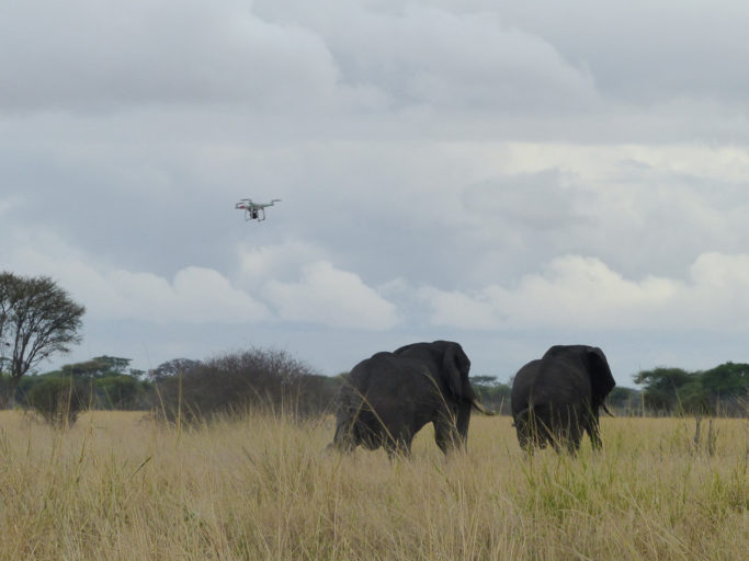
Even for that matter, drones, or unmanned aerial vehicles (UAVs), have rapidly transformed the face of the conservation industry. They have the potential to revolutionize conservation and spatial ecosystems. The core of conservation is monitoring of the species population and their habitats. Drones are most beneficial in tracking those animals that are shy and not easy to locate as they provide a direct aerial view of them. Thus, upholding the sanctity of their natural space without disturbing them. Thermal imaging feature provides effortless images post sunset and are also capable of capturing activities in the night time.
Traditional methods of gathering species populations and habitats information may be resource intensive, potentially inaccurate, difficult to authenticate and may pose a significant threat to human safety due to the presence of dangerous animals or environments.
UAVs provide the opportunity to obtain accurate data and high-resolution images in a better, faster, cheaper and safer manner. The use of drones in the conservation sector is not limited to only monitoring species and their habitats. Drones can be used for management purposes, technical services, and eco-tourism marketing, and law enforcement, anti-poaching and search-and-rescue efforts.
The technology deployed promises a better future for wildlife preservation as it interferes less with the environment of the animals and protects them from a distance. Moreover, these technologies would eventually help researchers track animals and learn more about their natural habitat.

